

“Halt soil salinization, boost soil productivity” is the theme of this year’s World Soil Day (5 December). As a country with a large coastline, saltwater intrusion has significant adverse impacts in Bangladesh. To address the land degradation due to salinization, the country should adopt a strategy for sustainable land management, opines Dr Jalal Uddin Md. Shoaib.
CONTEXT
In Bangladesh, the problem of soil salinity is a persistent threat to ecosystem services in both coastal lands and islands in view of its adverse effects on sustainable use of land and water resources. In the last 35 years, salinity has increased by around 26 percent in this country. Salinity intrusion is spreading continuously into the northern non-coastal areas as well (Mahmuduzzaman et.al. 2014). Large areas of land remain fallow in the dry season (January–May) because of soil salinity, lack of good quality irrigation water and problems with water control, mostly drainage (Haque 2006, Mondal et al. 2006, SRDI 2010).
After the Krug Mission Report[1] in 1957, embankments were constructed to protect farms and farmers from sea water intrusion and tidal water in 1960s and 1970s. Total 139 coastal embankments or polders (Box 1)) have been constructed to protect low-lying lands from tidal inundation and salinity intrusion through large-scale and small-scale Flood Control Drainage (FCD) and Flood Control, Drainage & Irrigation (FCDI) projects. Those interventions protected 1.2 million hectares of land, supporting 8 million inhabitants.
| Box 1. Polders The polders- a Dutch word, refers to an area enclosed by embankments/dikes made as an independent hydrological unit. These are only connected with surrounding natural water system through manually operated water control structures. The immediate results from the coastal polder were very significant for the socio-economic development of coastal lives and livelihoods. But from early 1980s, poldered area started to get cut-off from the surrounding tidal riverbed due to rapid sedimentation and declined river gradients. Yet, despite past and on-going investments in constructing and maintaining the polder embankments and sluice gates, drainage congestion and risk of flooding increased while agricultural productivity remains low and poverty is rife (CGIAR 2015, Jakia 2017). |
By and large salinization process remained unaddressed due to poor or absent embankment maintenance and protection from coastal surges, conflicting interest on water resource usage, non-functional sluice gates, lack of community involvement, leasing internal canals, deforestation of mangroves, etc. SRDI 2010 database reveals progressive increase of saline area from 83.3, 102.0 and 105.6 million hectares in 1973, 2000 and 2009 respectively.
DRIVERS OF SOIL SALINITY
The major drivers of soil salinity are as follows:
- capillary rise of saline ground water in dry season,
- depth to ground water table,
- irrigation with saline GW,
- sea/river water inundation in both protected and unprotected polders,
- seepage of saline water to adjacent agricultural lands of the polders,
- shrimp farming and poor water governance and polder management,
- conflict among land users (deliberate invasion of sea water for shrimp, salt etc.),
- grabbing canals/creeks in the polders,
- cyclone and storm surge, sea level rise (due to climate change), etc. (Rashid and Islam 2007, Haque et al. 2008, Rasel et al. 2013).
These drivers vary spatially throughout the coastal region and influence the soil salinity status. Nevertheless, the impacts of these drivers are interdependent and indivisible. In addition, there is spectacular mismatch of effective interaction between community involvement (social capital) and usage of natural resources (all flora and fauna-natural capital) to bail out from the vicious cycle of poverty in the area (Nandy and Islam, 2010). Moreover, the impact of polderization on livelihood vulnerability is not straightforward and is therefore still poorly understood (Nath et.al. 2019). Commonly, soil salinity becomes evident when evapotranspiration becomes much higher than rainfall and surface soils becomes dry (hydrological environment). Peek period of soil salinity is observable during April/May when salt crust is formed on land surface and it decreases with the advent of monsoon.
ADDRESSING SOIL SALINITY
The coastal region witnesses two spectacularly different scenarios:
- soil salinity in dry season and
- water logging (as most of the lands are flooded up to 3 feet) in rainy season.
Thus, there is no one solution to halt or reduce land degradation due to salinization. Simple techniques of soil management to wash salinity, changing landforms, applying vermicompost to improve soil health, discontinuing capillary zone, fresh water reserve, aquaculture, dibbling seeds, etc., are adopted in the coastal region. These methods are either practiced in isolation or in combination of two or more approaches.
Coastal regions need a strategy for sustainable land management (Box 2).
|
Box 2: Sustainable Land Management (SLM) The productivity and sustainability of a land-use system is determined by the interaction between land resources, climate and human activities. Especially in the face of climate change and variability, using land the right way given a set of biophysical and socio-economic conditions, and implementing SLM, is essential for minimizing land degradation, rehabilitating degraded land, ensuring the sustainable use of land resources (i.e. soils, water and biodiversity) and maximizing resilience. SLM encompasses established approaches such as soil and water conservation, natural resource management and integrated landscape management (ILM). It involves a holistic approach to achieving productive and healthy ecosystems by integrating social, economic, physical and biological needs and values. It contributes to sustainable and rural development. |
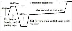 Fig-1: A typical example of changing landforms in coastal saline areas (Gurung TR and Azad AK (Eds.) 2013, Shoaib JU 2013)
Best practices in SLM for coastal region to address salinization were documented by different professionals and institutions using the “World Overview of Conservation Approaches and Technologies- WOCAT tool” (https://www.wocat.net/en/). Those SLM could be grouped according to the areas they addressed:
- Changing landform to manage soil and water resources,
- Adopting salt tolerant crops to circumvent salinity,
- Introducing green infrastructure (mangrove and other tree plantation) to protect embankment and tidal surge, and
- Increasing fresh water reserve- effective usage of internal creeks.
Widespread adoption of changing landforms is practiced in south-western coastal areas. Figure-1 describes a typical sketch of the process of changing landforms for coastal soil and water resource utilization (Gurung and Azad 2013, Shoaib 2013).
Following this approach, farmers of the coastal region in Bangladesh are growing year-round crops (rice, vegetable, fish, etc.) by changing landforms to halt and/or reduce soil salinity by dissolving salt in rainy season, reduce capillary rise of shallow ground water by keeping soil surface covered in dry season and usage of water resources for aquaculture in the same parcel. This type of approach is practically three dimensional to halt or reduce soil salinity:
- Year-round vegetable on raised desalinized dykes/bunds,
- Kharif-2 rice on level land and
- Aquaculture in the ditch (excavated area) either one side of the land or around the land.
The configuration of changing landform depends on a farmer’s choice, fund availability, market, land conditions, expected crops to be grown and the hydrological situation. These practices are spectacular in AEZ-13: The Ganges Tidal Floodplain, and some areas in AEZ-18: Young Meghna Estuarine Floodplain areas. A few pictorial presentations of halting soil salinity in western coastal region (AEZ-13) of Bangladesh follow.
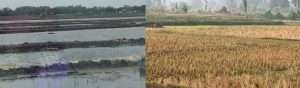 Bare dykesbunds of shrimp Gher / A typical single crop land in coast and converted land in distance
From L to R: Bare dykes/bunds of shrimp Gher; A typical single crop land in coast and converted land in distance; changed landform to grow vegetable, rice and fish; changed landform to grow fruit, vegetable and fish. Photo: Shoaib JU.
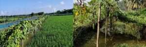 Changed landform to grow fruit, vegetables, rich and fish
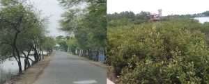
From L to R: Cropping on soil heap (tower gardening) to skip water logging and salinity in homesteads; year-round vegetable on raised land in saline area; Babul (Acasia Nilotica) along coastal road to protect breaching; mangrove outside the polders; Photo: Shoaib JU.
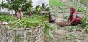 Cropping on soil heap (Tower gardening) to skip water logging and salinity in homesteads/ 6-Year-round vegetable on raised land in saline area
WAY FORWARD
Managing soil salinity is not very challenging in the coast, but necessitates integrated institutional framework. The central approach to halt salinization in Bangladesh should be focused on efficient polder management with a very strong soil and water governance framework to stop or reduce saline water intrusion from sea/river and limit ground water abstraction for irrigation.
The process deserves multisectoral (GO/NGO) involvement with rational policy support and investment. Some interventions are (but not limited to) enabling fresh water storage in creeks/khals/rivers in the polders, establishing effective internal drainage system to beat water logging, restricting deliberate saline water intrusion for shrimp or salt, limiting abstraction of groundwater (saline) for irrigation and developing supervised green infrastructure (developing mangrove and tree plantation along embankment, etc.)
The strategy may include:
- Identify and document SLM best practices, preferably following “WOCAT tool” (https://www.wocat.net/en/) and scale-up/scale-out for wider use in the landscape. There are several best practices adopted by farmers that includes indigenous practices and/or promoted by GO/NGO initiatives to manage soils to grow crops in dry season, like watermelon, vegetable, fruit, etc. Department of Agricultural Extension (DAE) could lead a team of local GO/NGO.
- Creating strong awareness about polder management.
- Research and development of polder management (Like Tidal River Management-TRM, changing landform etc.) and establishing continuous monitoring system. Bangladesh Agricultural Research Council (BARC) may lead the process.
- Implementing “Soil Doctor” program to involve the community in promoting sustainable soil management program (FAO 2020).
- Establishing green infrastructure in coastal region (along embankments, dykes, gher, etc.) and
- Compliance of “World Soil Charter” by all stakeholders (government, private, individual, etc.) to establish an achievable soil management framework.
REFERENCES
CGAIR. 2015. The Polder promise: Unlashing productive potential in Southern Bangladesh. https://wle.cgiar.org/news/polder-promise-unleashing-productive-potential-southern-bangladesh
FAO. 2020. Manual for the implementation of the Soil Doctors Global Programme at the country level – A farmer-to-farmer training programme. Rome. https://www.fao.org/documents/card/en/c/ca7492en
FAO. 2015. Revised World Soil Charter. Rome. https://www.fao.org/3/I4965E/i4965e.pdf
Gurung TR and Azad AK (Eds.). 2013. Best practices and procedures of saline soil reclamation systems in SAARC countries. Bangladesh Agricultural Research Council (BARC).
Haque MA, Jharna DE, Uddin MN and Saleque MA. 2008. Soil solution electrical conductivity and basic cations composition in the rhizosphere of lowland rice in coastal soils Bangladesh, Journal of Agricultural Research 33(2): 243–250.
Haque SA. 2006. Salinity problems and crop production in coastal regions of Bangladesh, Pakistan, Journal of Botany 38(5):1359-1365. https://www.researchgate.net/publication/228724784_Salinity_problems_and_crop_production_in_coastal_regions_of_Bangladesh#:~:text=Among%20these%20affected%20areas%2C%20around,(25).%20.
Jakia Akhter. 2017. Polderization in Bangladesh and its consequences. DOI: 10.13140/RG.2.2.32150.14406.
Mahmuduzzaman Md, Ahmed ZU, Nuruzzaman AKM, Ahmed FRS. 2014. Causes of Salinity Intrusion in Coastal Belt of Bangladesh. International Journal of Plant Research 4(4A): 8-13. DOI: 10.5923/s.plant.201401.02.
Mondal MK, Tuong TP, Ritu SP, Choudhury MHK, Chasi AM, Majumder PK, Islam MM and Adhikary SK. 2006. Coastal water resource use for higher productivity: Participatory research for increasing cropping intensity in Bangladesh. In Environment and livelihoods in tropical coastal zones: Managing agriculture-fishery-aquaculture conflicts, ed. Hoanh CT, Tuong TP, Gowing JW, and Hardy B. Wallingford: CAB International.
Nandy P. and Islam AM. 2010. Climate Resilient Coastal Zone Development in Bangladesh: Participatory Governance for Common Resources Management. In: Ramanathan AL, Bhattacharya P, Dittmar T, Prasad MBK, Neupane BR. (eds) Management and Sustainable Development of Coastal Zone Environments. Springer, Dordrecht. https://doi.org/10.1007/978-90-481-3068-9_4
Nath S, van Laerhoven F and Driessen PP. 2019. Have Bangladesh’s Polders Decreased Livelihood Vulnerability? A Comparative Case Study. Sustainability 11(24): 7141. https://www.mdpi.com/2071-1050/11/24/7141/pdf.
Rasel, HM, Hasan MR, Ahmed B and Miah MSU. 2013. Investigation of soil and water salinity, its effect on crop production and adaptation strategy. International Journal of Water Resources and Environmental Engineering 5(8): 475–481. https://doi.org/10.5897/IJWREE2013.0400.
Rashid M and Islam MS. 2007. Adaptation to climate change for sustainable development of Bangladesh agriculture. Bangladesh country paper for the 3rd session of the Technical Committee of Asian and Pacific Center for Agricultural Engineering and Machinery (APCAEM), November 20–21, Beijing.
SRDI. 2010. Saline Soils of Bangladesh. Soil Resource Development Institute SRMAF Project, Ministry of Agriculture, Bangladesh. http://srdi.portal.gov.bd/sites/default/files/files/srdi.portal.gov.bd/publications/bc598e7a_df21_49ee_882e_0302c974015f/Soil%20salinity%20report-Nov%202010.pdf
Shoaib JU. 2013. Usage of Gher boundaries for cropping (Bangladesh). https://qcat.wocat.net/en/wocat/technologies/view/technologies_1171/
WOCAT SLM Data base. (n.d). The Global database on sustainable land management, a primary recommended database by UNCCD. https://qcat.wocat.net/en/wocat/
Footnote
[1] The Krug Mission Report, 1957 was a product of a study on flood control and water management in East Pakistan after the disastrous floods of 1954, 1955 and 1956 that drew world attention.
 Dr Jalal Uddin Md. Shoaib, a soil scientist specialized in soil survey, remote sensing and watershed management, is Chair, Pillar-4, Global Soil Partnership (GSP). He served as Chief Scientific Officer at the Soil Resource Development Institute (SRDI Bangladesh) and was instrumental in establishment of the Soil and Water Conservation and Research Center at Bandarban, Bangladesh. He previously served as former UNCCD Country Consultant to set national targets to achieve Land Degradation Neutrality (LDN) by 2030 and as Global Grants Reviewer of Rotary International (RI)- as a technical Cadre Advisor of the Rotary Foundation. He is General Secretary, Soil Science Society of Bangladesh, Paul Haris Fellow (PHF) of Rotary International, and is associated with many national and international professional organizations. He can be contacted at jalalshoaib52@gmail.com.

Add Comment